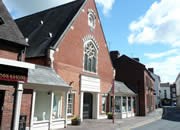
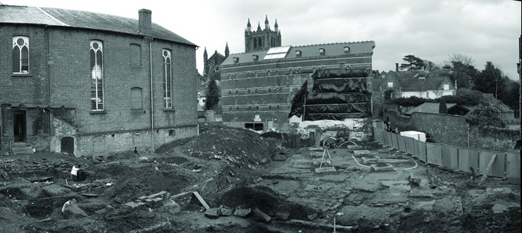
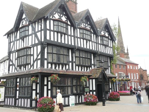
Ledbury: Methodist Chapel
 Historic Environment Record reference no. 19847, Ordnance Survey grid reference: SO 7098 3800
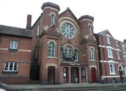
A Methodist Chapel shown as such on the 1887 1st edition OS map.
A Wesleyan Methodist Chapel in the Homend in Ledbury. It was built c.1849 and re-fronted in 1884. Some time in the 20th century the porch enclosing the area between the two towers was added.
(Information taken from Royal Commission on the Historical Monuments of England, Chapels and Meeting-houses in Central England,1986)
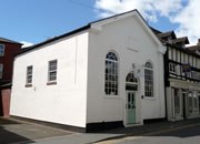
Ledbury: Baptist Chapel
 HER no. (Awaiting entry onto database), OS grid ref: SO 7098 3810
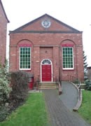
A Baptist Chapel at Homend, built in 1836 (Luke Tilley says 1831) for a newly-formed church. It is a three-bay brick-fronted chapel with two tall windows in arched recesses, and was designed to seat 300. Inside the chapel is a lead lined baptism tank in front of the pulpit.
The chapel is marked on the first edition OS map of 1886.
(Information taken from Royal Commission on the Historical Buildings of England, Chapels and Meeting-houses in Central England (1986) and Luke Tilley, Illustrated Guide to Ledbury)
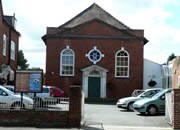
Ledbury: Congregational Chapel
HER no. 19890, OS grid ref: SO 7116 3770
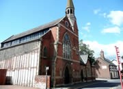
A former Congregational Chapel on High Street, Ledbury. The congregation was formerly a Presbyterian one, which developed in the late 17th century. The chapel stands on a site east of the Market Hall. It was rebuilt in 1852 and closed around 1970.
The original Congregational chapel on this site dated from about 1607 and the congregation formerly included Presbyterians and Congregationalists, but for the past 200 years the pastors have been Congregationalists. The first chapel was demolished in 1749 and the replacement was small and damp. This building was replaced with the present structure in 1852, which was designed to seat 500.
The west front is of brick with stone dressings in three bays; it is of unusually high quality. The main cornice at the top of the front elevation is capped by urn finials and bears the inscription: "REBUILT ANNO DOMINI MDCCCLII" (1852).
(Information taken from Royal Commission on the Historical Monuments of England, Chapels and Meeting-houses in Central England (1986) and Luke Tilley, Illustrated Guide to Ledbury)
Ledbury: Mission Hall
 HER no. (awaiting entry onto SMR database), OS grid ref: SO
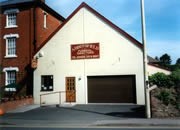
A Mission Hall situated in Bye Street, which was founded by Lady Henry Somerset. The hall was later known as the Apostolic Church. The hall has since undergone obvious alterations, including the removal of the windows at the front and the replacement of the corrugated iron structure with a weather-boarded one.
The building is now used as an undertaker's premises.
(Information taken from Luke Tilley, Illustrated Guide to Ledbury)
Leintwardine: Primitive Methodist Chapel
HER no. 36925, OS grid ref: 4219 7616
A ruined Primitive Methodist Chapel with foundations and north wall surviving. The building is shown as still standing on the 1963 OS map.
(Information taken from Fred Bluck, Methodism in the Marches)
Leintwardine: Congregational Chapel
HER no. 8543, OS grid ref: SO 4047 7425
A Congregational Chapel and attached schoolroom. The chapel and schoolroom are situated on Tipton's Lane and dated 1869 and 1881 on respective plaques. The building is made of sandstone rubble with sandstone and polychromatic brick dressings and Welsh slate roofs. The chapel is of three bays with a polygonal west end. It is aligned east to west and the former schoolroom is attached at right angles at the east end.
At the south elevation the chapel has three lancets to the left with cast iron glazing bars, above which are moulded brick labels. There are blue and brown brick jambs and quoins. Beneath the lancets are cogged brick strings. The east end of the roof has a bell-cot with trefoil headed openings to each side with moulded imposts and a cornice.
On the top of the chapel is a small sandstone spire with a weathervane.
In 1989 the building was put up for sale.
Leintwardine: Methodist Chapel
HER no. 21080, OS grid ref: SO 4047 7403
Situated on Church Street in the centre of Leintwardine, now a private house. On the 1846 tithe map the building is shown as a chapel and land under the ownership of Messrs Langford. On the OS map of 1865 it is shown as a Primitive Methodist Chapel.
Leominster: Congregational Chapel
 HER no. 19535, OS grid ref: SO 4956 5909
Situated on Burgess Street at the turning for Leominster Library car park. Price noted in 1775 that Presbyterian deserters in Leominster had formed themselves into a congregation in the 17th century. They originally had a chapel in Etnam Street but had moved to Burgess Street in 1719. The chapel is now a shop selling household goods.
Leominster: Apostolic Church
HER no. 23527, OS grid ref: SO 4958 5868
Situated on Gateway Lane, a 20th century Apostolic Chapel , now redundant, which has been converted into a dwelling.
Leominster: Methodist Chapel, Ivington Green
HER no. 18234, OS grid ref: SO 4655 5620
A Primitive Methodist Chapel about three miles south-west of Leominster.
There was a society of eight members in Ivington and Newtown in 1848, and an earlier chapel probably existed as there were two services each Sunday in 1882. By 1884 the members numbered only five but this must have improved as the present chapel was opened in 1907. The foundation stone was laid by Mrs. G. Page, the Mayoress of Leominster. The Reverend James was the minister and the chapel was built by J. Watkins and Sons. The land had been donated for use as a chapel site by Mrs. Hurry and her sisters.
In 1944 there were 15 members. The chapel was later closed with its last services being held in January 1975.
This chapel is now in private ownership and has been sensitively converted into a small house.
Leominster: Wesleyan Methodist Chapel, Burgess Street
 HER no. 19536, OS grid ref: SO 4956 5912
Situated on the north side of Burgess Street, opposite the Congregational Chapel. It was erected in 1861 but after the Reunification of Methodists it was no longer used and is now a shopping walkway known as "Chapel Walk" with shops on either side.
The chapel was built in the 1860s after the membership of the Wesleyan Methodist Chapel got too large for its predecessor just up the road (HER 16306).
It cost £985 and seated up to 300 people. By 1877 the membership had grown from 30 to 94 and continued to flourish.
World War II was to have serious consequences for this chapel. By November 1939 blackouts were being put up and a decision was made to only hold services in the chapel on alternate weeks for the duration of the war. Soon after, the schoolroom in Burgess Street was requisitioned by the Army and the secretary of the chapel was asked to disconnect the electricity supply to the schoolroom and to block up the access between the chapel and the schoolroom. In January 1940 the majority of services were being held at the Primitive Methodist Chapel on Green Lane.
By 1944, with an end to the war in sight, the future of the Burgess Street chapel was being considered. Part of the building was still being used by the Army and at one point it was considered as a British Restaurant, but it was decided that it was unsuitable. There was discussion about building a new Methodist Chapel but the funds were not available. In 1945 the pews and organ were put up for sale and the pulpit bible and hymn books were distributed to the surrounding country chapels.
The building was sold in 1945 for £2,400.
Leominster: Wesleyan Methodist Chapel, Burgess Street
 HER no. 16306, OS grid ref: SO 4948 5909
On the south side of Burgess Street, near the junction with Rainbow Street and less than 100 yards from the Wesleyan Methodist Chapel on the opposite side of the road. The chapel was erected in 1841 and was the first purpose-built church of the Wesleyans in Leominster, although they had been in the area since the late 18th century. It is thought that the Wesleyans had moved from a meeting place in a Malt House on Etnam Street (now Leominster Museum).
John Wesley's visit to Leominster in August 1746 probably marked the beginning of Methodism in the immediate area. A small society was subsequently founded by a Mr. Walker and they met in various private houses around the town.
At the beginning of the 1820s Methodist preachers frequently came to Leominster, preaching in Corn Square and the Bargates. In 1839 the preachers in the Kington Methodist Circuit (to which Leominster belonged) requested a chapel, the same year that the Primitive Methodists had decided to build a chapel in Green Lane.
The building of a permanent chapel encouraged the growth of membership and less than 20 years later a larger chapel was needed. This was placed just down the road on the opposite side (HER 19536).
The original Methodist Chapel building has now been converted into a hairdressing salon.
Leominster: Primitive Methodist Chapel
HER no. 36926, OS grid ref: SO 4937 5915
In Green Lane, Leominster, a good sized red and blue brick chapel.
In 1825 Primitive Methodism was established in Leominster, and in the same year it was reported as an authorised body to the Quarterly Meeting.
The Primitive Methodists held meetings in many different buildings around the town, including a house in New Street, a room in Bridge Street and an old building in Broad Street thought to be on the site of the old Corn Market. In 1839 a chapel had been built in Green Lane which became known as the Green Lane Room, which stands next to the present chapel.
In 1913 a pamphlet was published telling the history of the Sunday School in Leominster. It recorded that "On October 12th 1852, the Leominster Primitive Methodist Society passed the following resolution: 'that there be a Sabbath School commenced at Leominster on Sunday, 17th October'". By 1871 there were six teachers and 30 pupils, and by 1912 these numbers had increased to 102 scholars and 20 teachers.
In 1870 it was decided that a larger chapel needed to be built and in 1873 the present chapel was erected. It cost over £400 - a large sum in those days. Later the inside of the chapel was renovated, creating more space inside. The side aisles were removed and a wide central one made, and the choir stalls were removed and a platform built.
Sometime in the 1990s a large brick porch the width of the original building was added.
(Information taken from Fred Bluck, Methodism in the Marches)
Leominster: Baptist Chapel
 HER no. 35593, OS grid ref: SO 4990 5880
Situated on the south side of Etnam Street in the town of Leominster. The chapel is red brick with a central set of double doors that face the street. The doorway is surrounded by a pediment and pillars. Above the pediment is a circular window with keystone detail at each 90º angle and coloured glass. Either side of the doorway are two large windows with semicircular heads and keystone details.
The chapel was built in 1771 at the expense of Mrs Mary Marlow, who also built a Minister's house and two cottages for the poor widows of the Baptist Church.
Behind the chapel lies the Baptist burial ground.
The chapel is still in use today.
(Information taken from Rev. D.A. Brown, The History of the Free Churches of Leominster)
Leominster: Moravian Chapel
 HER no. 36927, OS grid ref: SO 4962 5865
Situated on the east side of South Street in the town of Leominster. The chapel is of thin, light red brick and lies side on to the road. On the side elevation are three large windows edged in yellow stone and with prominent keystone details. The roof is slate and just off centre has a small bellcote with weathervane. To the one end of the chapel is an adjoining Minister's house and behind the chapel is the burial ground.
The foundations for this chapel were laid on 29 April 1760, and the opening ceremony was held on 18 January 1761. In 1872 schoolrooms for the chapel were built. The chapel is still in use today.
(Information taken from Rev. D.A. Brown, A History of the Free Churches of Leominster)
Leysters: Methodist Chapel
HER no. (awaiting entry into database), OS grid ref: SO 5500 6300
A Methodist chapel was erected at Leysters in the 1880s. The chapel had been closed and sold off by 1940 and a house has now been built on the site upon which it stood on the main road through the village.
(Information taken from Fred Bluck, Methodism in the Marches)
Lingen: Methodist Chapel
HER no. 35569, OS grid ref: SO 3658 6688
A Primitive Methodist Chapel, which is marked as such on the 1st Edition Ordnance Survey map of 1884. It is situated just to the south of the village of Lingen. The chapel is also marked as a place of worship on the modern OS map.
The chapel is of red brick with yellow brick dressings around the corners, doors and windows. Above the pointed arch of the door is a date-tablet of similar architectural style, which reads "Primitive Methodist Chapel 1877, The Lord Loveth The Gates of Zion".
Surrounding the chapel is a small graveyard.
Lingen: Methodist Chapel
HER no. 35567, OS grid ref: SO 3663 6892
To the west of Birtley Cross and just to the north of Lingen village is a building which was marked on the 1st Edition OS map as a Primitive Methodist Chapel. It is no longer marked as a place of worship on modern OS maps.
Linton: Chapel
HER no. 36627, OS grid ref : SO 6736 2600
At Gorsley Common is a building which is simply marked as "Chapel" on the 1903 2nd Edition OS map. It is still marked as a place of worship on modern OS maps.
Little Birch: Methodist Chapel
HER no. 36618, OS grid ref: SO 5128 3212
A Wesleyan Methodist Chapel which is on the 1887 OS 1st Edition map but not on modern OS maps.
Little Cowarne: Chapel House
HER no. 35776, OS grid ref: SO 6048 5056
On the 1885 OS 1st Edition map there is a building marked as "Chapel House", but there is nothing marked on modern OS maps.
Little Hereford: Methodist Chapel
HER no. 35586, OS grid ref: SO 5478 6958
A chapel that is marked on modern OS maps and on the 1885 1st Edition is labelled Primitive Methodist.
Llangarron: Methodist Chapel
HER no. 3962, OS grid ref: SO 5249 1908
A two storey single bay Methodist Chapel at Llangrove.
Llangarron: Congregational Chapel
HER no. 34517, OS grid ref: SO 5230 1934
A former Congregational Chapel adjoining a former rectory (Llangrove Cottage). The building is of coursed and squared sandstone rubble with ashlar dressings and a hipped slate roof.
The entrance is on the north and has a moulded cornice and stringcourse. There is a cast iron canopy supported on four pillars over the entrance with a semi-circular window above the doorway.
Inside the chapel there are panelled shutters to the windows and a panelled dado and central cupola.
(Information taken from English Heritage's Listed Building description)
Llanveynoe: Baptist Chapel
HER no. 36612, OS grid ref: SO 2843 3267
A Salem Particular Baptist Chapel shown on the 1st Edition OS map but not on current ones.
Llanwarne: Baptist Chapel
HER NO. 36619, OS grid ref: SO 4805 2789
A Particular Baptist Chapel shown on the 1887 OS map but not on the current ones.
Llanwarne: Methodist Chapel
HER no. 36620, OS grid ref: SO 4961 2609
A Primitive Methodist Chapel marked on the 1887 1st Edition OS map but not marked on current maps.
Llanwarne: Methodist Chapel
HER no. 36621, OS grid ref: SO 5211 2799
On Windmill Hill, near to Llandinabo, is a building that was once a Primitive Methodist Chapel (1887 OS map) but is no longer marked as a place of worship.
Longtown: Ebenezer Baptist Chapel
HER no. 31803, OS grid ref: SO 3250 2844
This chapel is not listed on the 1st edition OS map but it is shown on the 1996 version, and there are records from before this date. In 1910 the chapel had 78 members and 55 Sunday School Scholars. Longtown Vicarage also holds copies of the gravestone inscriptions.
The chapel is situated to the south end of the village, close to the Crown Inn pub. Along the side are four windows and by each window a date stone laid by different people. The chapel is known as the "Old Ebenezer Chapel". One of the date-tablets says that it was laid by Dr. Thain on June 13th 1889.
Longtown: Salem Baptist Chapel
HER no. 31802, OS grid ref: SO 3215 2932
This chapel is shown on the 1st edition OS map, and in the National Library of Wales at Aberystwyth is a handwritten version of the chapel's history up to 1910.
The chapel was built in 1842 on donated land. The opening service was held on 5th July 1843. In 1895 the membership of the chapel was 35, with 30 Sunday School attendees. In 1905 this number had risen to 79 members and 53 Sunday School attendees.
The chapel is situated to the north end of the village, not far from the Police Station. A date-tablet on the outside of the building reads: "Salem Baptist Chapel 1843".
Longtown: Methodist Chapel
HER no. 36614, OS grid ref: SO 3485 3052
A Bethel Primitive Methodist Chapel at Lower Maescoed. It is marked as a Bethel Chapel on both the 1st Edition and modern OS maps.
Lugwardine: Chapel
HER no. 38210, OS grid ref: SO 551 411
A grey stone chapel on Lumber Lane in Lugwardine. Mr. Brian Hodges (minister in 2003) has informed us that this chapel is shown on the 2nd Edition OS map of 1905 as a Mission Chapel. The community here was initiated in 1820 and funded by William Godwin, the owner of the nearby prestigious Godwin's Tile factory. The present chapel was built sometime in the last quarter of the 19th century.
Inside is a Godwin tiled floor incorporating approximately 5,000 encaustic tiles. The building is not marked as a chapel on either the 1886 1st edition or 1973 OS maps, but is marked as a place of worship on the most recent OS map. The building is now used as a Evangelical Charismatic chapel.
Luston: Methodist Chapel
HER no. 35591, OS grid ref: SO 4865 6305
The chapel is located in the middle of the village of Luston in the north of the county. Unusually, the parish church is one mile from the centre of the village.
In the 1860s the land for the construction of the chapel was donated and the chapel built using money raised through public subscriptions. Twenty years later a strip of ground was purchased to enable access to the side windows and a small fuel storage shed was built.
In the 1950s the pulpit was replaced with one from the disused chapel at Stockmoor near Dilwyn.
The chapel had its own Sunday School, and the registers show that for the years between 1899-1910 and 1928-1964 attendance would vary between 40 down to two.
The date-tablet above the door of this chapel reads "Wesleyan Chapel 1862".
In 1962 the chapel celebrated its Centenary Service. A letter commemorating that service mentioned that numbers at the chapel had not always been good and on several occasions the chapel had been threatened with closure. The numbers in attendance continued to fall and in 1967 the Border Counties Commission Experiment decided to stop Sunday service at Luston.
However, due to the hard work of the community, Luston Chapel recommenced services in 1974 on the first Sunday of each month, and in April 1982 this was increased to two Sundays a month, with numbers attending varying between 10 and 20.
(Information taken from Fred Bluck, Methodism in the Marches)
Lyonshall: Baptist Chapel
HER no. 31479, OS grid ref: SO 3364 5547
A General Baptist Chapel marked on the 1st edition OS map as a chapel. It is situated in the village of Lyonshall, not far from the George Inn and the Post Office.
The chapel is very ornate with wonderful polychrome brick dressings. At the front of the chapel is a porch with a pointed arch doorway and to one side a tower with small arched windows. Down the side of the chapel are three sets of double windows with yellow brick dressings and central pillars.
Lyonshall: Mission Room
HER no. 26790, OS grid ref: SO 3405 5475
A Mission Room at Holme Marsh near Lyonshall; it is marked on the OS in an area that looks like a "Squatter Settlement". Nearby there is a medieval settlement and 17th century farms.
The building is of green corrugated iron with a simple doorway with a rectangular window on either side. It could easily be mistaken for a shed or workshop.
Lyonshall: New Street Methodist Chapel
HER no. 35602, OS grid ref: SO 3364 5673
New Street is a lane off the main Leominster to Kington road, equidistant between Pembridge and Kington but a good way from the village of Lyonshall. Just off this lane and up a slight bank is this red brick chapel, surrounded by trees and bushes. At the front three steps lead up to the front door, which has a semicircular window above it. On either side of the door are windows with round arches. There is also a window on each side wall.
An inscription on the building tells us that it is a Primitive Methodist Chapel of 1864.
Services were held at Lyonshall from the beginning of the 19th century, most probably in a nearby farmhouse. When this was no longer viable they were moved to an old railway carriage where they continued for a number of years.
The Quarter Day Meeting records for 4 March 1839 show that there were prospects for another two chapels at Ledgemoor and Lyonshall. By December 1843 little had been achieved and the minutes for this month record "That ground bee tried to bee got for a chapel at New Street". In 1860 a Mr. Barrow was given the job of trying to secure ground for a chapel; he was eventually successful and in 1864 the chapel at New Street was built with seating for 120 and at a cost of £133.
The membership of the chapel was never great:
| 1884 |
12 members |
| 1906 |
5 members |
| 1912 |
6 members |
| 1916 |
14 members |
| 1931 |
13 members |
| 1938 |
5 members |
When G.L. Harriman came as Pastor to Pembridge he wrote that "It had almost invariably five in the congregation, the three Misses Powell, sisters, to whose farm one usually went after the afternoon service to tea before pressing on to one's evening appointment, old Mr Duggin and Mrs Morris, a sprightly septuagenarian who played the organ and who would insist on me going to have tea with her before I left the circuit although she was not one of my members".
The chapel was closed sometime after 1962.
(Information taken from Fred Bluck, Methodism in the Marches)
]]>

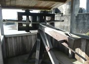 Other ways of attacking involved machines (known collectively as siege engines) that hurled missiles at the castle. These siege engines took three forms: the ballista (a kind of large crossbow), counterpoise machines (the trebuchetand the perrier), and the mangonel (a giant catapult). The ballista used the torsion method of propulsion. It was mounted on a wooden stand, and its arms were fastened to twisted ropes. The bowstring was then cranked back, and the increasing pressure put the ropes under strain. When the pressure had reached the right level, a release mechanism shot the missile towards its target. The ballista had a considerable range.
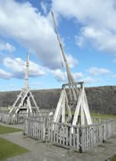 The perrier was the smaller of the counterpoise machines. It had a launching arm which pivoted on a bar, resembling a seesaw. To operate the perrier, a team of men pulled down on ropes fastened to one end. At the other end was a sling containing the missile. The missile's weight was affected by the force exerted by the men pulling on the rope, and when the rope was released the launching arm was levered forwards with great force, hurling the missile at speed. The perrier was relatively quick and easy to re-set and fire again. The trebuchet, on the other hand, was larger, heavier and slower to re-set. The downforce on its lever was provided by a ballast-filled box rather than a team of men, and it fired large rocks. The trebuchet's huge size and range made it the most effective of the siege engines.
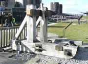 The mangonel was used to throw missiles, such as rocks and ceramic-encased incendiaries, high in the air. It consisted of a cradle, which contained the missile to be fired. The cradle was pulled back using twisted ropes and then let go, releasing the missile. The missiles used were relatively small compared to the size of the mangonel itself, but they could be shot with some accuracy.
 Ledbury Cottage Hospital (SMR 35707)
 Leominster Cottage Hospital (SMR 35708)
 A Congregational Chapel on Sherford Street. It was built in 1701, apparently at the expense of Grimbald Pauncefort of Clator Park.
 HER no. 35765, OS grid ref: SO 4045 5139