Herefordshire Through Time

Herefordshire Through Time
This section contains background and general information on selected projects carried out by Herefordshire Archaeology. Some projects are jointly funded by bodies such as Historic England or education bodies, who are working in partnership with Herefordshire Archaeology. There are various community-based projects that provide opportunities for members of the public to get involved in different ways. Contact details are provided where this is the case.
The Hereford Archaeological Research Framework document is a brief review of current understanding of the archaeology of the city of Hereford - its significance, its potential, and, above all, its gaps and its limitations, with a view to the identification of research priorities for the immediate future.
Excavation work carried out at Eaton Camp, Eaton Bishop in May 2012 was carried out by Herefordshire Archaeology on behalf of the Eaton Camp Historical Society and funded by the Heritage Lottery Fund.
During 2009 and 2010 Herefordshire Archaeology, with funding from English Heritage, carried out a study of the city walls and prepared a plan for their future. The plan addresses the issues of the physical condition of the walls and their maintenance, the need for improved public access and the use of the walls as a historic asset for enhancing civic pride and sustaining the economic development of the city as a whole.
The recommendations include urgent repairs to some sections of the walls, providing better public access and the creation of a signage scheme for interpreting the walls as well as a self-guided city walls walk.
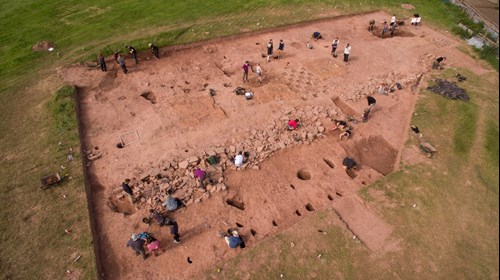
During the summer of 2010, Herefordshire Archaeology and Manchester University collaborated on the excavation of a prehistoric site in the Olchon Valley in south-west Herefordshire.
The Woodland Trust was been awarded a Heritage Lottery Fund grant to conserve and study Credenhill Park Wood, which it purchased in 2003. Credenhill hill fort - the largest in the Welsh Marches - stands within this wood. A six-week archaeological excavation was carried out at the fort in August and September 2007, under the direction of Peter Dorling of Herefordshire Archaeology. The team consisted of Herefordshire Archaeology staff members, local volunteers and Cardiff University students. These excavations are part of a longer-term project being undertaken in partnership with the Woodland Trust. This wider project will also involve the removal of conifer trees (planted in the 1960s) from much of the fort, and the restoration of the surrounding woodland to mixed deciduous cover.
The 2007 excavations featured in a Time Team Special documentary about hill forts that was made over the summer of that year and included footage of other Herefordshire sites. The programme was broadcast on Channel 4 television in June 2008.
Between April and May 2009, Herefordshire Archaeology carried out a four week season of excavation at New Weir Iron Works at Symonds Yat West.
The aim of the excavation was to try to identify areas where specific processes were taking place, to examine the evidence of those processes and to get some idea of how the site functioned. Little work has been carried out on forges of this date. This information gained therefore fed into the long-term management of the site and into its interpretation.
The site was in use from at least the 1590s up until the 1800s. It was known to be a forge for refining iron from nearby furnaces and to have incorporated a slitting mill, probably for nail and/or wire production, and later a rolling mill. The various forges, mills and hammers were powered by water wheels.
The project is an element of the "Overlooking the Wye" project funded by the Heritage Lottery Fund. This Landscape Partnership Scheme was designed to improve and promote enjoyment, understanding, accessibility, involvement, conservation and management of the historic environment in the landscape of the lower Wye Valley.
The aim of the Lower Lugg Archaeology and Aggregates Project (which ran from 2006 to 2009) was to improve understanding, management, protection and promotion of the visible and buried remains of past human settlement within the Lower Lugg Valley. The project was funded by the Aggregates Levy Sustainability Fund (as administered by English Heritage), and was managed by Herefordshire Archaeology (the archaeology service of Herefordshire Council).
The project stemmed from the development since the 1980s of large scale gravel quarrying in the Lower Lugg flood plain. Spectacular archaeological discoveries at Wellington Quarry have included the 1200-year-old remains of two of Britain's earliest known watermills, a Roman country estate, and the 4000-year-old burial of a local tribal leader.
These finds have confirmed that the Lower Lugg Valley has long been a significant area of intensive human settlement, and that nationally-important archaeological remains of this activity still survive. At the same time, given ongoing use of the Lower Lugg landscape for modern purposes such as gravel quarrying, farming and residential development, it is clear that effective management of the archaeological legacy of the Lower Lugg is a significant future challenge.
This was a data-cleaning and enhancement project, commenced in 2006 and completed in October 2008. It was funded by English Heritage as part of their national Urban Archaeological Strategy programme. New SMR records have where necessary been added and existing records checked, reorganised and re-mapped such that, it is hoped, virtually every archaeological trench excavated in the city and historic suburbs, and every monument, are now accurately located on Herefordshire Council's GIS.
An English Heritage-funded programme of aerial survey allowed the recording of archaeological sites and landscapes. The programme aimed to provide a record of cropmarks, large-scale projects in the landscape, provide support to urban characterisation projects and to maintain a record of sites under threat.
A significant development from previous aerial survey projects is the availability of a pilot at Gloucestershire Airport. This has enabled us to start to get a much more systematic coverage for the south of the county, which until now has been very sparsely covered by reconnaissance flights. Many previously unrecorded earthworks have been now been photographed and will be added to Herefordshire's Historic Environment Record.
The Roman Families Project was carried out by Herefordshire Archaeology on behalf of Herefordshire Council. It was made possible by funding from the Ministry of Defence Armed Forces Community Covenant Grant.
The Roman Families Project aimed to involve and attract families, youth groups and local inhabitants of the Credenhill Garrison community in the archaeological investigation of Roman Credenhill, in particular the area immediately around the Roman town of Kenchester (Magnis). The project aim was to enable families from both the military and civilian realms (both adults and youth) to work as a team within an entirely different setting and acquire new skills and experiences through the process of archaeological investigation and event days. The project focused on an enclosure site within the Roman Park Playing Fields, Credenhill; a park owned by Herefordshire Council and maintained by the Credenhill Parish Council. Investigations of the site started in April 2014 with a geophysical survey. The results of this survey were used to guide a community excavation carried out between 7th and 27th July 2014. This report discusses the results of that excavation, along with the subsequent post-excavation analysis.
In 2000 the Croft Estate comprised 560 hectares of ground that has recently been expanded with the purchase of further former estate ground near Lucton. Two winter seasons of archaeological survey across the estate in 2001 and 2002 have demonstrated the remarkable preservation of earthwork remains across the five kilometre east-west extent of the estate. The major divisions of the area include now heavily planted land leased to the Forestry Commission, open common and former coppices, the parkland in the environs of the mansion, the surviving wood-pasture in and around Croft Ambrey, and arable fields and pasture on the lower slopes.
By the end of the 2002 season, both an inner and an outer ward of the medieval castle had been located with a moderate degree of confidence. Traces of narrow ditches and pits lines beneath the later demolition deposits and workshop area appear to indicate the presence of timber structures that represent an early (and possibly timber) phase of the castle. The mortuary Inventory for Sir James Croft in 1590 survives in a fragmentary state in the British Library. Research by Valerie Goodbury indicates that the rooms listed include both a hall and a chapel. A glazed heraldic floor tile fragment from the excavation matches those now partially flooring the parish church, and this, as well as the stained glass, may have derived from this chapel.
The excavation clearly indicates that we can trust the dendrochronology to specify the date of construction of the present mansion. This therefore means that the earliest terraced garden of the Elizabethan period belongs to the demolished mansion. Moreover, the Restoration period formal garden clearly used in its basal layers brick and tile (and other) demolition material from the same mansion, while being planned outwards from the present mansion.
Perhaps the most remarkable conclusion from the 2002 season's investigations concerns the present mansion. Herbert Croft, the second son of the Sir William killed in the Civil War, was a renowned cleric. He famously shamed Parliamentary soldiery intent on defiling Hereford Cathedral when Dean there, and was praised for his sober manner, by John Aubrey in his Brief Lives. It is no doubt of some significance that Herbert was appointed Bishop of Hereford in 1661. It was said that he used Croft as his country home when in the county, but not in residence at Hereford. As such, not only is Croft Castle a late addition to the corpus of Spenserian mansions, but it is also an unusual example of a mid-seventeenth century bishop's palace.
The Rotherwas Ribbon is an unusual and enigmatic Neolithic or Early Bronze Age linear structure consisting of a 6 to 8 metre wide burnt stone surface located within a hollow/cut. A 67m length of the Ribbon was identified, uncovered and partly excavated in 2007 during a PPG16 supported archaeological recording exercise in advance of the construction of the Rotherwas Access Road, Herefordshire. The structure was associated with a significant bone, pottery and flint artefact assemblage, and also appeared to be spatially and chronologically linked with a group of eight pits (six of which were filled with burnt stone) which were located immediately adjacent to the Ribbon. The Ribbon was also cut by two later (Iron Age/Roman?) ditches on broadly the same alignment, and itself cut an earlier linear feature. A group of six radiocarbon dates (obtained from carbonised hazel samples from two of the pits and a charcoal spread on the Ribbon surface) lie within a late 3rd/early 2nd millennium BC date range, and suggest that the last use of the feature was during this period.